|
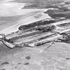
1957 - 1958
Lindøværftets opførelse. 7 luftfotos
|
B1739
Billeder
Munkebo Lokalhistoriske Arkiv
|
|
1959 - 1960
Diverse presse- og luftfotos fra Munkebo
|
F55
Billeder
Munkebo Lokalhistoriske Arkiv
|
|
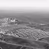
1958 - 1967
Stor samling luftfotos fra Ejendomsselskabet Lindø A/S.
|
B2300
Billeder
Munkebo Lokalhistoriske Arkiv
|
|
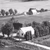
1930 - 1940
Risinges stuehus fra gårdsiden (formentlig)
|
B5520
Billeder
Munkebo Lokalhistoriske Arkiv
|
|
1950 - 1970
2 s/h luftfotos af ejendommene Boels Bro 4 og 6
|
B3357
Billeder
Munkebo Lokalhistoriske Arkiv
|
|
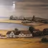
1960 - 1969
Affotografering af maleri af Ejner Kjærsbo formentlig med motiv fra Risinggården og Østergårds Mølle
|
B5224
Billeder
Munkebo Lokalhistoriske Arkiv
|
|
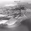
1958 - 1964
Den sydlige del af Munkebo med markering af blandt andet ejendommene Korshøj, Ølundgård og Stenlundgårds beliggenhed. samt Galgeholm.
|
B3585
Billeder
Munkebo Lokalhistoriske Arkiv
|
|
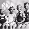
1870 - 1955
Diverse scannede fotos med motiver og personer fra gården Højvang i Munkebo.
|
B3107
Billeder
Munkebo Lokalhistoriske Arkiv
|